Property Record
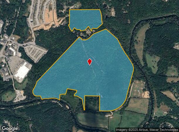
680 York Dr, Canton, GA 30114
NEARBY LISTINGS FOR SALE OR LEASE
Property Detail
680 York Dr
Atlanta-Sandy Springs-Roswell, GA
Dutch York Surv
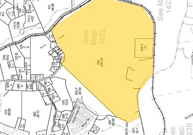
014N22-00000-098-000-0000
LL 241 242 263 266 14TH D PB 2 PG 175
Taxexempt
Cherokee
AE
Georgia
13057C0164E
240
2025
246.49 AC
2025
Cherokee County
090605
Atlanta
DEMOGRAPHICS near 680 York Dr
1 Mile
3 Mile
5 Mile
2024 Total Population
839
23,385
49,880
2029 Population
968
26,845
57,244
Pop Growth 2024-2029
+ 15.38%
+ 14.80%
+ 14.76%
Average Age
41
38
40
2024 Total Households
327
8,424
17,567
HH Growth 2024-2029
+ 15.29%
+ 14.96%
+ 14.97%
Median Household Inc
$63,375
$70,040
$80,107
Avg Household Size
2.60
2.70
2.70
2024 Avg HH Vehicles
2.00
2.00
2.00
Median Home Value
$260,185
$347,413
$372,459
Median Year Built
2001
1999
2001
Nearby Places
- Restaurants
- Banks
- Shops
- Fitness
- Groceries
Nearby Properties
Address
Land Use
TOTAL SIZE
Lot Size
Zoning
Address
Land Use
TOTAL SIZE
Lot Size
Zoning
242,502 SF
41.65 AC
PD
Address
Land Use
TOTAL SIZE
Lot Size
Zoning
244,451 SF
20.55 AC
PSC
Address
Land Use
TOTAL SIZE
Lot Size
Zoning
162,243 SF
29.44 AC
R-5
Address
Land Use
TOTAL SIZE
Lot Size
Zoning
260,621 SF
26.25 AC
RM-15
Address
Land Use
TOTAL SIZE
Lot Size
Zoning
369,520 SF
4.50 AC
ERC
Address
Land Use
TOTAL SIZE
Lot Size
Zoning
313,906 SF
28.96 AC
PD
Address
Land Use
TOTAL SIZE
Lot Size
Zoning
133,711 SF
22.23 AC
R-3
Address
Land Use
TOTAL SIZE
Lot Size
Zoning
80,795 SF
34.86 AC
PD-MIXED U
Address
Land Use
TOTAL SIZE
Lot Size
Zoning
239,139 SF
88 AC
PD-MU
Address
Land Use
TOTAL SIZE
Lot Size
Zoning
238,343 SF
38.77 AC
PSC
Address
Land Use
TOTAL SIZE
Lot Size
Zoning
204,826 SF
4.91 AC
PD
Address
Land Use
TOTAL SIZE
Lot Size
Zoning
241,482 SF
31.65 AC
PD
Address
Land Use
TOTAL SIZE
Lot Size
Zoning
270,248 SF
29.05 AC
PD-MU
Address
Land Use
TOTAL SIZE
Lot Size
Zoning
279,274 SF
23.46 AC
R-5
Address
Land Use
TOTAL SIZE
Lot Size
Zoning
489,988 SF
20.20 AC
LI
Address
Land Use
TOTAL SIZE
Lot Size
Zoning
24,586 SF
PD
Address
Land Use
TOTAL SIZE
Lot Size
Zoning
62,308 SF
7.57 AC
ERC
Address
Land Use
TOTAL SIZE
Lot Size
Zoning
197.68 AC
PD-MU
Address
Land Use
TOTAL SIZE
Lot Size
Zoning
79,672 SF
4.28 AC
PSC
Address
Land Use
TOTAL SIZE
Lot Size
Zoning
548,520 SF
70.10 AC
LI
Address
Land Use
TOTAL SIZE
Lot Size
Zoning
31,428 SF
10.21 AC
R-3
Address
Land Use
TOTAL SIZE
Lot Size
Zoning
178,576 SF
13.74 AC
GC
Address
Land Use
TOTAL SIZE
Lot Size
Zoning
687,913 SF
24.31 AC
LI
Address
Land Use
TOTAL SIZE
Lot Size
Zoning
111,630 SF
38.45 AC
LI
Address
Land Use
TOTAL SIZE
Lot Size
Zoning
159,645 SF
14.05 AC
RM-15
Address
Land Use
TOTAL SIZE
Lot Size
Zoning
191,105 SF
12.37 AC
PD
Address
Land Use
TOTAL SIZE
Lot Size
Zoning
151,121 SF
33.37 AC
GC
Address
Land Use
TOTAL SIZE
Lot Size
Zoning
78,236 SF
23.64 AC
PD
Address
Land Use
TOTAL SIZE
Lot Size
Zoning
66,710 SF
15.14 AC
PD-MU
Address
Land Use
TOTAL SIZE
Lot Size
Zoning
108,076 SF
15.50 AC
PD-MU
The World's #1 Commercial Real Estate Marketplace
Connect with us
© 2025 CoStar Group
The information above has been obtained from sources believed reliable. While we do not doubt its accuracy we have not verified it and make no guarantee, warranty or representation about it. It is your responsibility to independently confirm its accuracy and completeness. Any projections, opinions, assumptions, or estimates used are for example only and do not represent the current or future performance of the property. The value of this transaction to you depends on tax and other factors which should be evaluated by your tax, financial, and legal advisors. You and your advisors should conduct a careful, independent investigation of the property to determine to your satisfaction the suitability of the property for your needs.